

Raja Ampat
One of the Top 10 Best Diving Destinations in the World
The name Raja Ampat translates to Four Kings and originates in local mythology where four kings hatched from dragon eggs and went on to rule the four main islands of Misool, Salawati, Batanta and Waigeo.
The area covers over 40,000 km2 of land and sea with a population of around 50’000. A little over 8,000 make a living in Waisai, the capital of the Regency.

Raja Ampat Liveaboards
Raja Ampat Liveaboard – With hundreds of islands off the West Papuan coast, Raja Ampat – the Coral Triangle boasts the highest marine biodiversity in the world and should be on every diver’s bucket list! The underwater realm is a magical wonderland with healthy . . .

Dive Safari
Join Scuba Republic for a unique and unforgettable dive safari in amazing Raja Ampat. We explore the best dive spots around the Dampier Strait and spend the nights on exotic islands. During our surface intervals, we hike to stunning viewpoints. . .

Basecamp Raja Ampat
Scuba Republic Basecamp in Raja Ampat was made by divers for divers with a diver’s needs in mind. Our goal is to provide clean and comfortable accommodation, delicious food, world-class diving and excellent service. . .
How to get here
The Flight
The flight destination is Domine Eduard Osok Airport (SOQ) and you will land in Sorong. Direct flights are available from Bali (DPS) and Jakarta (CGK).
Bali (DPS) - Sorong (SOQ) : 3h 50m
Jakarta (CGK) - Sorong (SOQ) : 4h
The Ferry
Starting on 15 May 2025, this is the schedule for the ferry that leave from Pelabuhan Rakyat Sorong (click here to see the location) to Waisai Harbour and return.
9AM Ferry only available on Wednesday, Friday and Sunday
2 PM Ferry is still available everyday
It takes around 2 hours to get to Waisai.
Tickets are available at the harbour and the ticket counter opens at 8AM:
* VIP Rp 250,000
* Economy Rp 125,000
(both are with air conditioner)
Climate
According to the Köppen and Geiger classification, the climate in Raja Ampat is classified as tropical rainforest climate (Af).
Temperature
Air temperature in Raja Ampat averages year-round between 25C (night) and 30C (day). But due to the humidity it can often feel a lot hotter.
The water temperature stays between 28C and 30C throughout the year.
Seasonal changes
It can be windy all year round. During October – April the wind arrives from the northwest and central Raja Ampat is better protected than during May – September when the wind comes from the southeast. During the southeast monsoon months, the wind picks up and the sea can be choppy. Sea travel between islands can occasionally be limited, but otherwise water conditions for diving and snorkeling are not affected. However, this should not limit your experience as we adapt our schedules for your comfort and safety. Spells of rain occur throughout the year. However, during the southeast monsoon months, there is a slightly higher chance of rainfall, although rarely all day long. Rain is often short-lived and localized. As we are located near the equator, we enjoy a year-round day length of about twelve hours with stunning sunsets and sunrises around approximately 6.30 am/pm.
Marine Life
The Raja Ampat archipelago is part of the Coral Triangle, the heart of the world’s coral reef biodiversity.
Conservation International marine surveys suggest that the marine life diversity in the Raja Ampat area is considerably greater than any other area sampled in the Coral Triangle, making Raja Ampat quite possibly the richest coral reef ecosystem in the world.
According to Dr. Gerry Allen, “One of the drivers of this extraordinary biodiversity is the high diversity of habitats, ranging from shallow reef habitats which include fringing, barrier, patch and atoll reefs to deep channels between the main islands.”
Almost 75% of the worlds known hard coral species, 1400 species of reef fish, 17 types of mollusc, 13 marine mammal species and five of the world’s seven sea turtle species be found in the area.
The Indonesian Throughflow is one of the strongest currents of the planet. It channels a gigantic volume of water from the Pacific Ocean to the Indian Ocean through the straits that separate the landmasses of Indonesia. And Raja Ampat sits in the middle of it. Currents are known to reach up to eight knots and they carry with them millions of eggs and larvae that supply the region with both genetic diversity and food.
Massive aggregations of schooling fishes like fusiliers, jacks and snappers are one of the signature features of Raja Ampat. The coral cover is dense, healthy and bustling with colourful reef fish. Several cleaning stations let us observe both species of manta rays while they are serviced by wrasses.
White tip and black tip reef sharks are encountered almost daily with the occasional grey reef shark making an appearance. Our most charismatic shark is without a doubt the tasseled wobbegong, a well camouflaged ambush predator that can be found under ledges or sometimes curled up on top of table corals. The endemic Raja Ampat epaulette shark is more elusive, but equally popular with divers. It is also called “the walking shark” due to its ability to walk along the seafloor using an undulating, crawling motion.
On days with lower visibility when we are less distracted by the insane amount of fishes we like to browse through sea fans, hydroids and inspect coral bommies in order to find one of the several species of pygmy seahorses, colourful nudibranchs or elegant flatworms. A peak in a hole might even reveal an octopus or a curious mantis shrimp.
Diving
The Northwest Monsoon (October – April) brings plankton-rich water to the area which attracts plankton feeders, amongst them the elegant Manta ray. Expect visibility around 15-20m.
During the Southeast Monsoon (May – September) the water clears up and the visibility can be up to 40m. The aquarium-like conditions allow you to observe marine life that was previously hidden by the plankton-rich water. Especially local reef sharks, whose colours blend in easily into the background, can be seen in greater numbers.
Raja Ampat is well known for its currents, but we make sure that we choose dive sites that are appropriate for our divers based on their certification level, experience, and comfort. We check weather, tides, and currents when we plan and check the currents upon arriving at the dive sites.
There are several ways to explore the numerous reefs of Raja Ampat with Scuba Republic. Whether you like to spend a week on one of our charismatic liveaboards, hop from island to island with our adventurous 3-7 days Safari trips, or prefer to relax in our comfortable beach bungalows, we have an option for all tastes.
Nature
Raja Ampat’s islands are covered in a dense, nearly impregnable rainforest that is the natural habitat of a variety of species of birds, mammals, reptiles, and insects.
Over 250 avian species have been described in the islands, including many endemic species like Wilson’s Bird of Paradise (Waigeo and Batanta), the Red Bird of Paradise (Waigeo and Gam), Kofiau Island’s Kofiau Monarch, Paradise Kingfisher, and Waigeo’s Brujin’s Bush Turkey.
If you decide to stay land-based be prepared to be woken up by competitive birdsong. Lorikeets and Cockatoos are a common sight, their song occasional disturbed by a rhythmic thrumming. Not a helicopter – but a passing hornbill.
We share the area with many critters such as crabs, geckos, frogs, and monitor lizards. They come in different degrees of inquisitiveness, but none of them are dangerous. By far the cutest visitor is the critically endangered cuscus, a furry marsupial with a long tail roaming the trees at night.
Protection Status
The Raja Ampat Marine Protected Area (MPA) Network consists of seven individual MPA’s under regional or national jurisdiction in the heart of the Coral Triangle.
The livelihoods of more than 40’000 people spread across 135 villages depend on the preservation of the rich coastal and marine resources.
The goal of the MPA network is to establish “safe zones”, where fishing and commercial activity is limited to what the community needs. Key habitats and ecosystems, which are linked by the complex ocean currents of the Indonesian Throughflow are to be protected against exploitation that could impact not only the Raja Ampat area but other parts of the Indonesian archipelago and possibly the Coral Triangle itself.
In 2004 an alliance was formed between Conservation International (CI), The Nature Conservancy (TNC), WWF Indonesia and the local government of the Raja Ampat Regency. The idea was to establish 7 ecologically connected MPA’s that would cover an area of nearly 900,000 hectares and approximately 45% of Raja Ampat’s coral reefs and mangroves.
in May 2007, the network of seven MPA’s was formally declared by the government of the Raja Ampat regency.
Management
The conservation area is managed by the Technical Management Authority (UPTD) within the Department of Marine and Fisheries of Raja Ampat.
Efforts undertaken include zone regulations, zonation patrols, increasing public conservation awareness, encouraging sustainable tourism activities and increasing the economic benefits of conservation for local communities. These efforts require huge funding and cannot be fully supported by the Raja Ampat government’s financing capacity.
In order for preservation efforts to be financially sustainable the Raja Ampat Regency has implemented a Regional Public Service Agency (BLUD) in 2014 which allows for more flexibility to use non-tax government revenues generated by tariff charges. This is the first and only conservation area in Indonesia to implement the BLUD system.
The Raja Ampat Marine Park Entry Permit tag (or PIN) has been recently renamed the Tariff to Support Environmental Services in Raja Ampat and must be paid by every visitor to Raja Ampat. International visitors contribute IDR 1’000’000, Indonesian citizens and KITAP holders contribute IDR 500’000 , children under 12 years are free. The permit is valid for a year from the date of purchase.
Raja Ampat’s Marine Park Areas are part of a bigger network that consists of 20 MPA’s spread across the Bird’s Head Seascape in West Papua. Besides the Raja Ampat archipelago in the west, it also includes Cendrawasih Bay in the east and the Kaimana Regency and Triton Bay in the south.
Below is a short description of the individual MPA’s in Raja Ampat.
Dampier Strait MPA
Area: 336,000 ha
Location:
The coastal island of Gam and Mansuar, coastal Batanta Island and Coastal Salawati Island (Central RA)
Population:
With the close location to the district capital of Raja Ampat, the local government has determined Dampier Strait as the primary marine tourism area. In Dampier Strait, the six villages of Sawinggrai, Arborek, Sawandarek, Yenbuba, Yenwaupnor, and Arefi have been set as the main villages to experience cultural tourism.
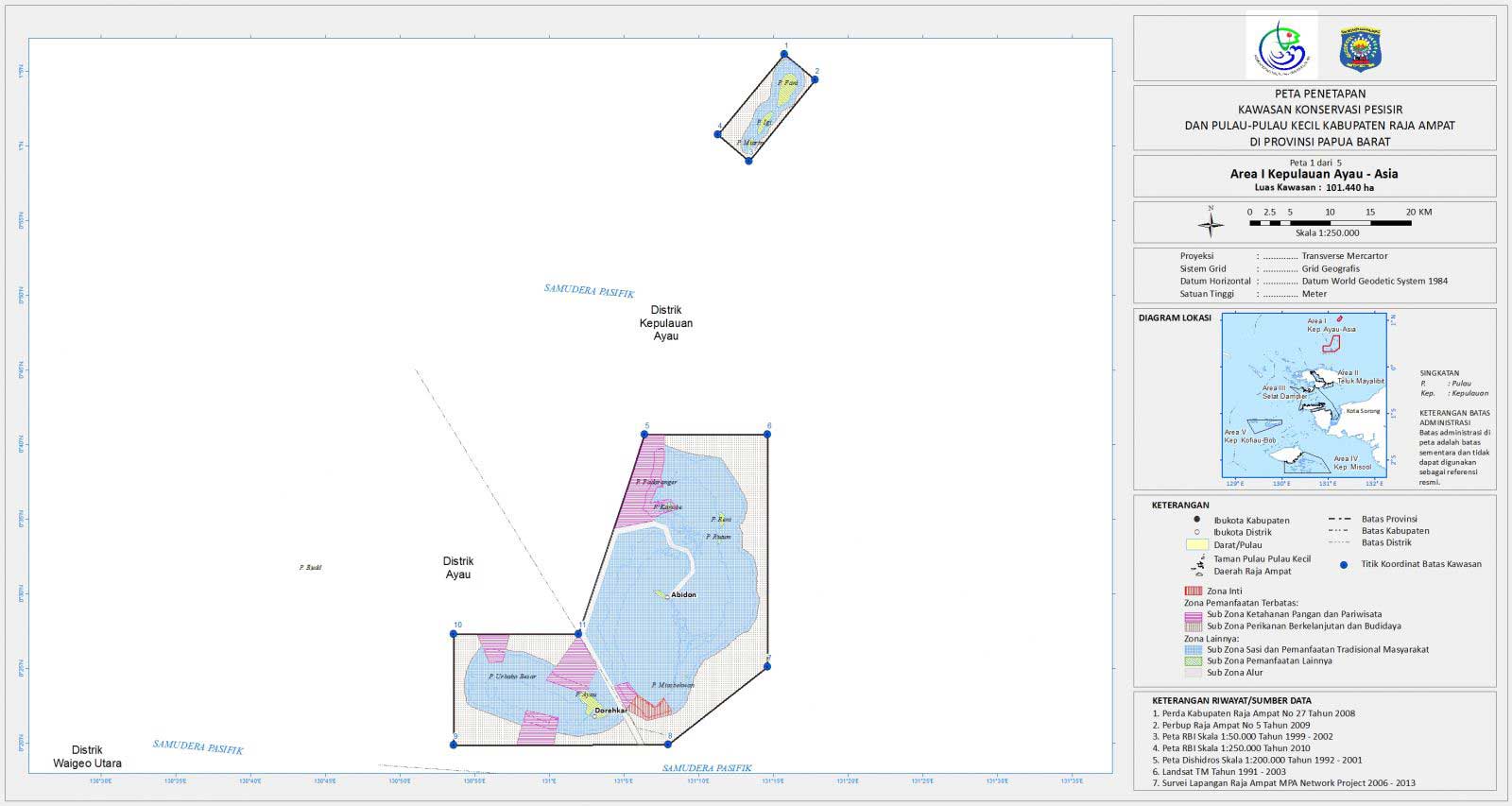
Ayau Asia MA
Area: 101,440 ha
Location:
Ayau district and Ayau Islands district (Northern tip of RA)
Population:
9 villages with a total population of 2,145 inhabitants. Historically, the population in Asia Ayau MPA are descendants from the Biak tribe, as well as the Wardo and Usba sub-tribes.
West Waigeo National MPA
Area: 271,630 ha
Location:
Sayang and Piai Islands and the Wayag island group (Northwest RA)
Population:
The islands in this MPA are uninhabited, but under traditional law, this region belongs to the Kawe sub-tribe, whose people live on the islands of Salio and Selpele.
Mayalibit Bay MPA
Area: 53,100 ha
Location:
Waigeo, in the districts of Mayalibit Bay and Tiplol Mayalibit
Population:
Mayalibit Bay belongs to the ancient Mayan tribe, indigenous to Raja Ampat. Approximately 2’000 people spread over 10 villages live in the Mayalibit Bay area.
Misool MPA
Area: 366 000 ha
Location:
Southeastern part of Misool and islands (South RA)
Population:
5,000 people living in 13 villages scattered throughout the region.
Kofiau MPA
Area: 170,000 ha
Location:
South RA
Population:
2,000 people spread across 5 villages. Local communities in Kofiau are descendants of the Betieu tribe.
Raja Ampat National MPA
Area: 60,000 ha
Location:
Raja Ampat Islands in Central RA